Alexander News Show+FollowChances grow for ‘Super’ El Niño by summer. Meteorologists are sounding the alarm: the Pacific is warming fast, and the odds of a “Super” El Niño emerging by summer are climbing sharply. That’s the kind of event that can reshape global weather — and Florida is right in the crosshairs. 🔥 What’s Driving the Concern Ocean temperatures in the eastern Pacific are rising earlier and more aggressively than expected. Several climate models now show a strong El Niño forming, with some pushing into super‑charged territory — the rare category that disrupts jet streams and weather patterns worldwide. 🌧️ What It Could Mean for Florida A powerful El Niño typically brings: - Wetter, stormier winters for South Florida. - Fewer Atlantic hurricanes, thanks to stronger wind shear. - Higher flood risks, especially in low‑lying coastal areas. For a region already dealing with king tides and chronic flooding, a Super El Niño could amplify those challenges. 🌍 Why Officials Are Watching Closely Super El Niño events are uncommon but historically impactful — from droughts in some regions to destructive flooding in others. With early indicators flashing, forecasters say the next few months will determine whether this pattern intensifies or stabilizes. #Elnino #Weather #Storms #Alexandernewsshow.60Share
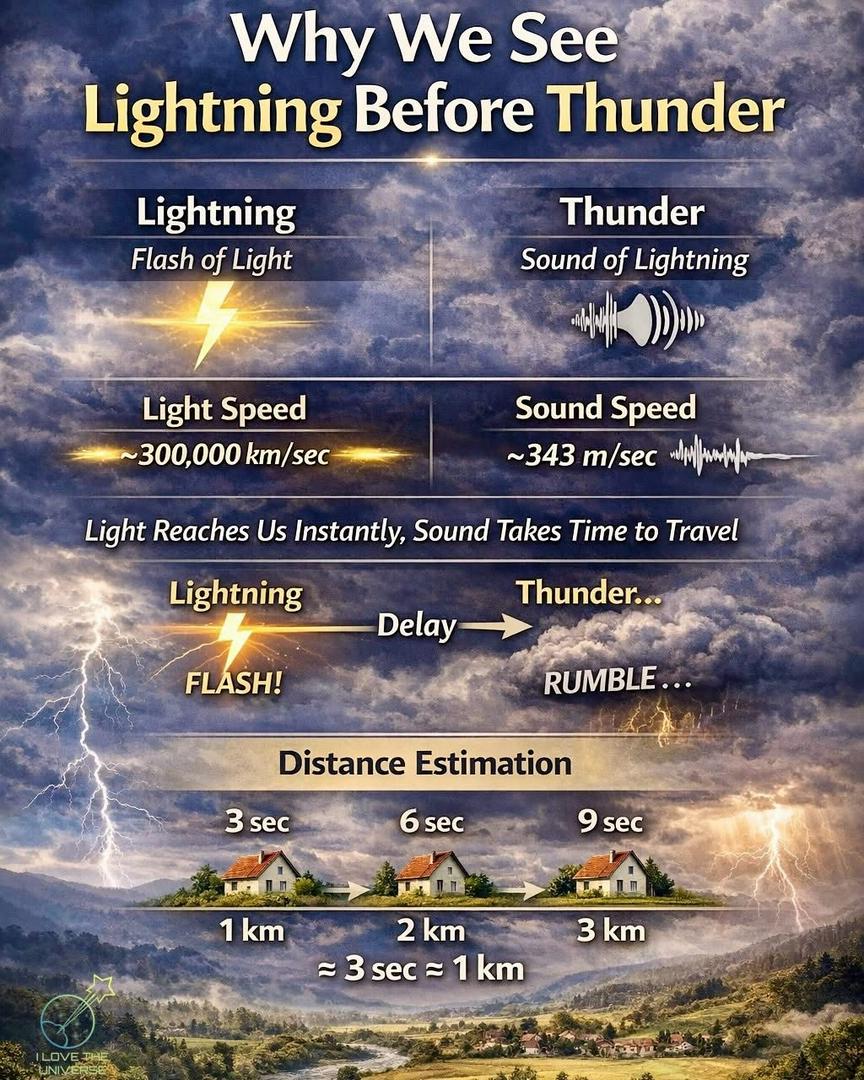
justme +FollowWhen a storm approaches, we always notice the lightning ⚡️ before we hear the thunder 💥 — and that’s no accident. Light travels at incredible speed, reaching our eyes almost instantly, while sound moves much slower through the air. That’s why thunder comes a few moments after the flash. But thunder is more than just a noise — it forms when the air is heated to over 30,000°C (54,000°F) in a split second. This intense heat causes the air to expand rapidly, producing a powerful shockwave we hear as a deep rumble. By counting the seconds between the flash and the sound, we can even estimate how far away the storm is. Nature isn’t just putting on a show — it follows precise physics every single time. #Lightning #Thunder #Science #Weather #Nature #Physics #DidYouKnow10Share
Alexander News Show+FollowEl Niño watch issued, what it means for Florida hurricane season. Florida may catch a rare break this year as federal forecasters place the Pacific Ocean under an official El Niño watch, signaling a likely shift toward conditions that historically suppress Atlantic hurricane activity. 🌡️ A Warming Pacific Signals Change Scientists are observing warming waters deep in the eastern Pacific—early signs that El Niño is re‑forming after a two‑year lull. Some models even hint at the possibility of a strong or “super” El Niño, driven by sea‑surface temperatures well above normal. 🌀 What This Means for Florida El Niño tends to strengthen upper‑level winds over the Atlantic, creating hostile conditions for tropical storms. That usually translates to: - Fewer named storms, - Reduced hurricane formation, and - Lower odds of major landfalls in Florida. For a state that has endured several hyperactive seasons, this shift could bring a much‑needed buffer during the peak months of 2026. 🔭 Why Officials Are Watching Closely While El Niño often works in Florida’s favor, forecasters caution that every season is unpredictable. Even quiet years can produce dangerous storms, and a single landfall can reshape an entire season’s impact. Still, the emerging pattern offers cautious optimism for residents and emergency planners. #Elnino #Weather #Hurricanes #Alexandernewsshow.00Share
TheMaineGirl +FollowSo it’s 32 degrees today. After being -14 to 4 degrees makes this weather feel like spring! It’s actually nice. So 32 degrees is alright!!! I can’t believe I can even say this but here we are… #Mainah #Maine #weatha #Weather #SnowyDays 51Share
GalaxyGoose+FollowDFW schools shut down again—how’s everyone coping?Another round of school closures is hitting the Dallas-Fort Worth area this Thursday, all thanks to stubborn patches of snow and ice that just won’t quit. Even with yesterday’s sunshine, overnight temps are expected to dip near freezing, making roads risky for early morning commutes. Most major districts—like Allen, Frisco, Plano, and Lewisville—are keeping doors closed, while others are still watching the weather. If you’re out and about, take it slow and watch for slick spots. How are these closures affecting your plans or routines? Anyone else juggling work and kids at home again? Let’s share tips and stories! #Weather #DFWWeather #SchoolClosures00Share
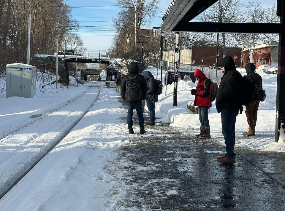
GalaxyGoose+FollowBoston’s T delays: How did your commute go?After Boston’s massive snowstorm, MBTA riders faced a tough Tuesday: Red Line trains stalled, shuttle buses replaced service, and more than two dozen commuter rail trips were canceled. Some folks even got stuck on a train halfway over the Neponset River! Despite official promises of a smooth recovery, many commuters found themselves braving the cold and waiting for late trains or buses. If you rely on the T, how did the delays impact your day? Did you see any creative solutions or major frustrations? Let’s swap stories and talk about what needs to change for next time. #Weather #BostonCommute #MBTA00Share
BubblyBobcat+FollowPublix stores in Alabama close early againPublix shoppers in Birmingham, Tuscaloosa, and Huntsville are facing another round of early store closures as freezing temperatures grip the region. Most locations shut their doors at 4 p.m. for the second day in a row, except for Flint Crossing Marketplace in Meridianville. With the National Weather Service warning of the coldest night yet—wind chills could drop as low as -5°—everyone’s being urged to layer up, bring pets inside, drip pipes, and check on neighbors. How are you handling these frigid conditions, and has your routine been thrown off by the early closures? #Weather #AlabamaWeather #Publix00Share
BubblyBobcat+FollowTriangle roads: Ice lingers off the highwaysMajor highways around the Triangle are looking much better after the winter storm, but don’t let that fool you—many neighborhood and side streets are still coated in ice. Folks who have to drive are finding that it’s easy to go from clear pavement to a slippery mess in seconds, especially on ramps and bridges. Plows are working, but with temps dropping again tonight, any melting could just refreeze. If you can, it’s still safest to stay put and let the sun and crews do their thing. How are road conditions in your area? #Weather #TriangleWeather #RoadConditions00Share
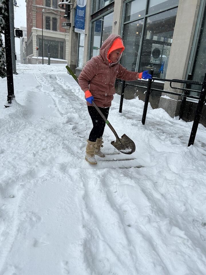
GalaxyGoose+FollowAkron’s snowy Sunday: Neighbors help neighborsAkron woke up to a real winter surprise—roads and sidewalks buried under heavy snow, making even a quick grocery run an adventure. Drivers took it slow, some struggling up slick hills, while folks like Louise Hershey found themselves shoveling nonstop outside downtown businesses. Even with a parking ban in effect, the city’s spirit showed up strong: coffee shop regulars braved the weather, and neighbors pitched in to clear paths. It’s a true test of patience and teamwork. How are you handling the snow? Any tips for staying safe or stories from your street? #Weather #AkronSnow #CommunityStrong00Share
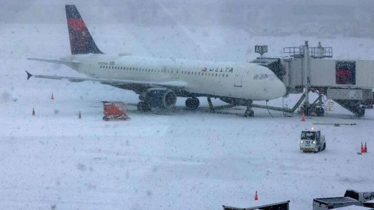
BubblyBobcat+FollowBoston’s travel plans frozen by record stormTravelers at Logan Airport are facing a near standstill after the biggest winter storm in years dumped over 18 inches of snow on Boston. With only a handful of airlines operating and more than 500 flights canceled at Logan alone, the airport feels almost deserted. Airlines are waiving change fees, but anyone with a flight scheduled should double-check their status before heading out. The airport expects to be back to normal by Tuesday, but today, patience is the name of the game. How are you coping with the travel chaos? Share your stories or tips below! #Weather #BostonWeather #LoganAirport00Share